supervision of construction and executive survey using the technology of laser scanning
The executive survey conducted at each stage of construction. The executive documentation is the result of geodetic surveys and the executive can be presented in text or in graphical form. It reflects the actual execution of design solutions, ie the actual position of the object of capital construction and its elements.
Traditional methods of using measurements of roulette, plumb and level required to attract a large number of human resources and take up a lot of time on the production of field work. The presence of the human factor directly affects the accuracy of measurements made.
In this situation, the most versatile and efficient method is the method of three-dimensional laser scanning.
Laser scanning - a technology that allows to create digital three-dimensional model of the object, presenting her a set of points with spatial coordinates. The principle of the scanner is based on measuring the distance to the object using a laser range finder and determination of two angles of the direction of the laser beam, which makes it possible to calculate the spatial coordinates of the point of reflection of the laser beam. Digital building model can be represented by a set of hundreds of thousands or millions of pixels.

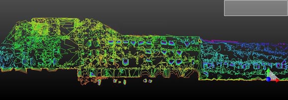
Facade. Deviations from the plane.

Facade. Point model. As a result of stitching 9 scans.The results of our work can be represented as:
- Results of measurements of 3D scanner (a cloud of points) that will allow you to build a model of the building;
- A precise model of the geometry of the object;
- A precise model of the geometry of the object, indicating deviations from construction documents;
- Plans, sections, cross sections;
- Measurement drawing;
- Reduced project documentation of the facility including all elements of design and elements of infrastructure facility in accordance with the requirements of SNIP.
Depending on the complexity of facing your problems and the budget allocated for their solutions can be obtained from our model, varying degrees of detail and accuracy:
- The object in general and / or individual criticism of its elements with varying degrees of detail - that on the basis of measurements in the model may be shown in items ranging in size from 1 cm and larger;
- The relative position of parts of structures and infrastructure of the building can be determined with an error of no more than 1-2 cm;
At your choice measurements and / or model of the object can be presented in formats DXF, DWG, PDS, PDMS, DGN.


