Layout act-drawing of the setting of the red lines for the project of territory planning in Moscow region, Shchelkovsky district
1
Customer:
"SK Podmoskovnie zori" ltd.
Project:
5812
Address:
Moscow region, Shchelkovsky district, village shchevelkino
Period:
2012
Heads:
Head architect: Nozdracheva P.V.
Assistents:
Head architect: Soloviev I.V.
Architect: Ponomarenko E.V.
Visualizer: Kotliar I.O.
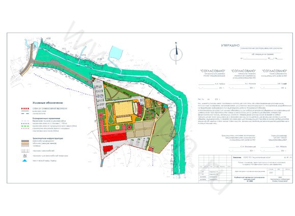
Proposals to establish red lines
Design of the red lines in the "Project of the area planning of equestrian sports center in Moscow region, Shchelkovo district, village. Schevelkino. " The red lines are shown in the drawing area plan that is part of the main (approved) part of project planning.
In accordance with the Town Planning Code of the Russian Federation, "the red lines - lines that refer to existing, planned (modified, re-formed) boundaries of common areas, the boundaries of the land on which there are power lines, communication lines (including those of outside plant ), pipelines, roads, railway lines and other similar structures.
"Public Areas - areas that are free to enjoy an unlimited number of persons (including squares, streets, driveways, embankments, squares and boulevards)."
The red lines are installed on the proposed access road linking the area of equestrian sports complex with a highway "Oseeva - Nikiforov - Medvezhie Ozera - Shevelkino ", as well as on lake Shalovka part of the territory.
Proposals to establish red lines, as well as design, layout drawings of the act meets the requirements of the legislative, legal and regulatory documents, including:
Urban Development Code of the Russian Federation of December 29, 2004 № 190-FZ;
The Land Code of the Russian Federation of 25.10.2001 № 136-FZ;
Resolution of the Government of the Moscow region from 19.06.2006 N 536/23 "On approval of the composition and content of the draft plan area, the preparation is carried out on the basis of territorial planning documents of the Moscow region and on the basis of territorial planning documents of municipalities of the Moscow region";
"Standards of allotment of land to accommodate the road and (or) road service facilities", approved by the Government of the Russian Federation of 02.09.2009 № 717;
TSN PZP 99 MO (TSN 30-303-2000 MO), "Planning and construction of urban and rural settlements";
SP 42.13330.2011 "SNiP 2.07.01-89 *. Urban Development. Planning and construction of urban and rural settlements ";
SNiP 2.05.02-85 * "Highways";
Water Code of the Russian Federation of 03.06.2006 № 74-FZ;
RDS 30-201-98 "Instructions on how to design and establish red lines in the towns and other settlements of the Russian Federation", adopted by Resolution of Construction Committee of Russia on April 6, 1998 № 18-30.
The red line on the driveway is installed on the south side of the roadway at a distance of 18.00 m from the axis of the road, taking into account the norms of allotment of land to accommodate the road technical category IV. On the north side of the roadway area of common use is combined with the territory of the public lake Shalovka. The red line is installed on the coastal strip from north lake Shalovka at a distance of 20.00 meters from the shore of the river. On lake Schalovkakrasnaya the line is installed on the coastal strip at a distance of 20.00 meters from the shore of the river from the territory of the equestrian sports complex.
Established by the red lines are required to comply with all stakeholders in the construction of urban development of new and reconstruction of existing facilities, as well as the formation of land boundaries. Approval of the red line does not entail the termination of the rights of businesses and individuals on the existing land and other real estate, and is the basis for subsequent decision (if necessary), making the seizure, including by foreclosure, land for implementation of state and municipal needs for the development of transport and engineering infrastructure.
Line Indent set to determine where the allowable placement of buildings, structures and facilities. Line indentation is set on the access road at a distance of 5 meters from the red line on the south side of the roadway.
Line indent in the future may be adjusted at the stage of architectural design.
The points are tied to the boundaries of the calculation of geodetic coordinates in a coordinate system in 1963 for the subsequent development of the red lines in the surrounding areas streets and roads.
Below is a list of coordinates of points of fracture of red lines.
Architectural laboratory offers the full range of services: from the initial permits, the development of all project stages to approval of projects and supervision.