Territory`s survey project with deployment multistorey living houses
1
2
3
Customer:
"InvestStroy" Ltd.
Project:
23/09 ПМТ
Address:
1st district, Povarovo, Solnechogorsk, Moscow region
Heads:
Chief architect of the project: P.Nozdracheva
Chief engineer of the project: A.Natarkina
Assistents:
Lead specialist: T.Morozova
Architect: E. Pismarova
Architect: S. Chistyakova
Total land area: 15.0 hectares
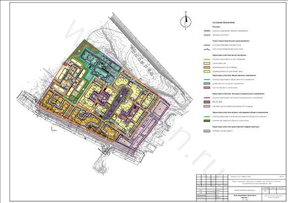
The territory surveying project of the deployment of high-rise apartment buildings with built-in and attached non-residential premises on the 1st floor of the 1st district of the urban settlement Povarovo Solnechnogorsk municipal area is developed in accordance with the approved "project planning area" (extract from the record number 48 of 09.12.2008g. Commission city Planning and the formation of the architectural appearance of Defense, Resolution № 47 of 06.04.09g. municipal Head of the urban settlement Povarovo Solnechnogorsk municipal district of Moscow region).
This work was performed in accordance with the Land Code of the Russian Federation, the Town Planning Code, snip, TSN and other regulations of the federal and territorial level.
The aim of the taskis to establish the boundaries of objects (buildings, structures, etc.) in the 1st district of the urban settlement Povarovo Solnechnogorsk municipal district, taking into account existing standards, planning restrictions, environmental requirements, engineering, organization of transport services.
The objectives of the project surveying the territory of the 1st district include:
The establishment of land boundaries of the existing and projected capital construction projects;
Develop proposals for the establishment of areas of the public easements;
Preparation of documentation for the development of urban land plans.
The design takes into account the results of the division of territory settlement and regulatory features of planning and spatial organization of the territory in accordance with the project planning of urban settlements Povarovo Solnechnogorsk municipal area.
Functional-area planning organization is adopted on the basis of the existing scheme of the territory (basic plan) with preservation of the existing two-storey section of dwelling houses and shops in the north-western part of the planned neighborhood.
The project planning area has proposed construction of residential high-rise buildings with built-in and attached service facilities on the site of the demolished fund.
Building perimeter is the nature of the organization of the inside spaces, which are united by a system of pedestrian connections.
The average number of floors of the projected construction - floors 12-14, with a decrease in the direction of the saved buildings, 16-story building is presented in the form of accents along the main axis of the pedestrian district.
The main compositional axis represents the boulevard that goes perpendicular to the road, "Spoon-Povarovo-Friday", which are placed along the residential group with built-in and attached service facilities.
In the north-western part of the district provides for construction of kindergartens and primary location of secondary schools in the existing kindergarten building to be reconstructed.
The whole territory of the neighborhood being improved, thanks to sites adult recreation, games, children's and sports grounds.
Territory falling within the protection zones from industrial enterprises and the October Railway, proposed for placement of garages and open parking. Part of the existing garages are reconstructed.
In the courtyards of apartment buildings and a recreational area of the projected (Boulevard) provides underground garages
Current situation.
Projected area is located in the central part of Solnechnogorsky municipal district in north-western part of the settlement Povarovo. The area of the projected area - 13.5 m.
boundaries of the projected area from the north - forest lands, from the east - forest land in the 50-120 m ROW October MOR direction, from the south - the territory of the industrial zone, the south-west - highway "Lozhki-Povarovo-Friday", etc. - the land of JSC "Niva", 100 meters - the territory of treatment facilities.
Residential development.
On the territory there are 23 houses, including a 2-storey houses, a three-story, single dormitory.
existing housing stock has the following parameters:
total area - 14.9 sq m, including a dormitory;
population - 844 people;
average provision of a total area of residential buildings - 17 65 m2 per person.
storeys on the fund is distributed as follows:
one-story building of dwellings - 1.1%,
building two-story apartment buildings - 94,9%;
building three-story apartment buildings - 4,0%.
Residential buildings № 10,11,12,15,17 area of 2.35 square meters are in disrepair and are intended to be demolished.
The objects of cultural and community purposes.
From objects of cultural and community purposes are: kindergarten, four shops, offices, outbuildings and garages.
The existing nursery with the occupancy of 110 seats is located in a separate building and has an area equipped with for walks, games and physical training.
Functional use of the territory.
Most of the territory is occupied areas of residential development - 6.54 hectares.
Plots public facilities occupy 1.37 hectares (part of the kindergarten -0.53 m, -0.7 m sections of garages, areas of communal use (EMG TP) -0.03 ha plots objects of trade and domestic, 0.11 ha).
Other areas cover 4.92 hectares:
area green space common areas (0.6 hectares),
outbuildings (1.2 hectares),
administrative area public buildings (0.12 ha),
undeveloped area (3.0 ha).
estimated area of 7.91 hectares (93.5 sq m / person.), which characterizes a very low intensity of use of the area.
density housing is 1885 square meters of total area / ha, which is 2.5 times less than the statutory rates for low intensity of use of the area (4.4 - 5.4 sq. m. total area / ha).
potential reserve housing development in the district is its douplotnenie due to the development of free areas and the demolition of dilapidated Foundation.
Architecture and planning organization of areas, town planning regulations.
The projected area as the object of valuation is the number one district in the urban settlement Povarovo Solnechnogorsky municipal district of Moscow region.
In accordance with the architectural and planning solution, the demolition of the projected area is assumed: the housing stock in the amount of 9,8 square meters the total area (including the demolition of the building dormitories), office building, 3 stores and outbuildings.
the design district number 1 of the mountains. the village. Povarovo used - blocks of high rise buildings of 10 to 16 floors.
on the residential neighborhoods will be located 11 residential buildings with a total capacity of 148.645 square meters of residential housing, including housing stock -143.205 square meters and built-attached premises -5.44 square meters
density housing will be 10.80 thousand square kilometers. meters of total area / ha, which corresponds to the normative parameters of high-intensity use of the area under reconstruction.
proposed for construction of model projects.
Rationale for boundaries households.
Regulatory and planning rationale for the boundaries of land made on the territory of the blocks bounded by the road network.
given in Appendix "K", "TSN PZP - 99 Defense" recommended specific parameters for the calculation of housing areas include the following parameters:
built-up area of houses,
greenery and landscaped area,
site for adult recreation,
children's playground,
site for fitness and for economic purposes,
approaches and entrances to buildings, sidewalks,
parking space for temporary storage of vehicles.
per regulations surrounding territory housing index calculation part of the population, defined on the basis of the size of the total area accommodation and the provision of 20 square meters. meters of space per resident.
Architectural laboratory offers the full range of services: from the initial permits, the development of all project stages to approval of projects and supervision.