Introduction
Surveying project
territory with the placement of roadside service multi Ltd.
"Navigator-MSK" is designed according to the requirements:
- Town Planning
Code;
- Land
Code of Russian Federation;
- snip, TSN and
other applicable laws and regulations and technical regulations in
the field of urban development.
Under
Town Planning Code of Russian Federation projects related to land surveying documentation
land planning. Project surveying the territory to be granted,
designed to establish the boundaries of undeveloped land,
planned to provide developers for construction.
Surveying project
territory is made on the basis of topographic mapping in scale 1:500
made Ltd. "Topography and geographical
Bureau "in 2011-2012 ..
Offers for the surveying of the territory.
Considered
site is located in the north-western part of the municipality of Lenin
district, Moscow region, as a part of a rural settlement Vnukovo and borders:
from the north - a new direction Borowski
highway, then 70m area AZK "Delta gas stations" within the venue
administrative, business, public, commercial, facilities
cultural, social and household purpose, with the north-east -
area green space special, then to 60m -
Pond; east - area individual residential development on
Rasskazovka, from the south - the territory of individual
residential development on Rasskazovka, then to 90m - Borovskoe highway, west
- The territory of forests located on forest land. Are on site
countryside, are utilities. The project area
subdivision includes land that is registered in
State Real Estate Cadastre (cadastral number 50:21:100211:0580), with
Type of land - land for industry, energy, transport, communications,
radio, television, computer, land for space
activities, defense, security, and other special
application, providing accommodation for road service. Also
land surveying project design includes areas for
placement of entry, exit and the acceleration and deceleration of the territory of the band placement
motorway service area and placing the entrance to the transformer
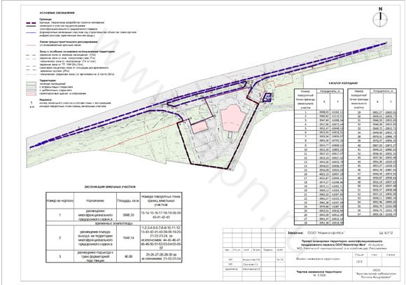
substation. Development boundary surveying project displayed in the drawing
surveying the territory. The coordinates of the turning points of the boundary of the draft
surveying: 1-2-3-4-5-6-7-8-9-10-11-12-13-14-15-16-17-18 -
19-20-21-22-23-24-25-26-27-28-29-30-31 -32-33-34,
presented in Table 2.
Area of the
site design surveying project is 5994.16 m2.
Under
architectural and planning organization of the territory determined by the project
plan, the area delimited for land information, which
presented in Table 1.
The boundaries of zones
with special conditions of use of the area are presented in accordance with
planning restrictions, certain materials planning project
territory.
Table 1.
|
The number in the drawing
|
Purpose
|
Area, sq.m.
|
Non turning points
land boundaries
|
|
1
|
placement
multifunctional roadside service
|
3998,33
|
13-14-15-16 -17-18-19 -
38-39-40-41 -42-43
|
|
temporaries
|
|
2
|
placement
entry-exit to the territory
multifunctional roadside service
|
1949,14
|
1-2-3-4 -5-6-7-8-9-10 -
11-12-13-43 -42-41-40 -
39-38-19-20 -21-22-23 -
24 except:
44-45-46-47-48-49-50 -
51-52-53-54 -55-56-57
|
|
3
|
accommodation entrance to
substation
|
46,69
|
25-26-27-28 -29-30 for
exception: 31-32-33-34
|