The purpose of the implementation of the project documentation is: the development of the territory of the Master Plan first stage of construction to the definition of the launch pad, under "Landscaping and landscaping" in the M - 1:500.
Development of design documentation is made on the basis of:
Surveying in the M - 1:500 performed LLC "geopolitics";
developed and approved the "Project layout area with the placement of high-rise buildings with built-in and attached rooms on the first floor at the address: Moscow region, Solnechnogorsk municipal district, town Povarovo, district number 1 (Extract from the Minutes № 48 of the Commission on Urban Development and the architectural appearance of the territories Moscow region dated 09.12.2008, the case number 847/08);
Decision № 47 of 06.04.2009 on Approval of the project planning area with the placement of high-rise buildings with built-in and attached facilities on the ground floor at the address: Moscow region, Solnechnogorsk district, town Povarovo, Povarovo village, district number 1.
Development of design documentation carried out in accordance with the requirements and subject to the following regulations:
TSN PZP-99, MO;
TSN 30-303-2000 MO;
Sanitary 2.2.1/2.1.1.1200-03;
The area of land included in the municipal program Solnechnogorsk municipal district of Moscow region "Development of built-up areas of the urban settlement Povarovo Solnechnogorsk municipal district."
The site is located within an emerging residential development and its functionality is not contrary to the perspective of urban situations.
The site is not included in the boundaries of the proposed protected areas of regional significance, not in the area of the planned allocation of capital construction projects of regional significance, is not included within the boundaries of the territories reserved for the construction and renovation of the Moscow region TsKAD.
Characteristics of the site.
The territory in question is located in the central part of Solnechnogorsk municipal district in north-western part of construction Povarovo.
Boundaries of the site development of the territory on a stage of construction:
from the north and north-east - the existing low-rise buildings;
from the east and south-east - the territory of the industrial zone;
from the west and north-west - territory dacha;
from the south-west - highway "Lozhki-Povarovo-Friday."
The terrain is mostly bias swings - 2.5 - 3.5 m.
Architecture and planning organization area.
The construction site refers to the IIB climate Subarea II climatic region. Estimated winter air temperature for heating -26 ° C.
On the territory there are four (4) a 2-storey houses, 2 shops, there are outbuildings and garages.
Planning restrictions are: the 50-foot sanitary-protective zone of the industrial area, the sanitary-protective zone of the engineering infrastructure, the 100-meter strip of withdrawal from the October Railway, Red Line A / D Lozhki-Povarovo-Friday.
The area within the boundaries of developed and approved the project planning area - 15 hectares. The area of the proposed site (within the boundaries of design documentation) under the first phase of construction - 4.14 hectares.
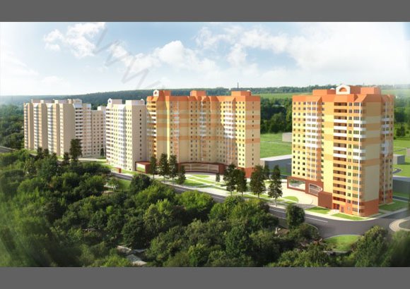
The first phase of construction is provided along the road Lozhki-Povarovo-Friday, organized by three groups of living with built-in and attached service facilities (launch pad), and parking garages for parking cars.
Entry and exit the territory is part of the road Lozhki-Povarovo-Friday.
All entrances to the residential premises are located by vnutridvorovye space. To comply with fire safety around the house provides the fire passage width of 5.5-6.0 meters.
In the project proposal are designed guest parking at 118 m / m (launch pad - 44 m / m), which corresponds to the regulatory requirements.
For storage of individual owners of vehicles required - 300 m / m x 1,540 thousand. = 462 m / m According to the draft plan provided for the territory of 479 m / seats.
The main highway - highway "Lozhki-Povarovo-Friday" meets "Scheme of traffic," developed "Dorstroy - 21" and within the red lines is 36 m (from the axis of a / d - 18m) ("layout drawings of the act establishing the red- lines ", as agreed by GUP MO NIIP Urbanism"). To ensure the safety of pedestrians through highway "Lozhki-Povarovo-Friday" provides a pedestrian crossing.
Relationship with other areas of construction Povarovo routes by urban passenger transport and taxi.
In addition, the district is located within walking distance from the railway station Povarovo October Railway.
Functional use of the territory.
Functional organization of the territory-planning the first phase of construction is adopted, based on the development of new territories according to the project planning area. Existing homes, shops and Combining subject to demolition.
In functional terms the projected area is composed of three zones: residential buildings, green spaces and public housing and public purpose. First phase of construction is divided into two sections:
launch pad - three residential group (2.54 ha)
garage complex, which includes reconstruction of existing garage and construction of new buildings, including - 4-storey garage complex (1.6 hectares - the total land area) area, mainly located in the buffer zone from the production area .
Launch pad construction is formed by three groups of residential high-rise buildings with built-in and attached service facilities. Building perimeter is the nature of the organization of the spaces, which are united by a system of pedestrian linkages from which to log into the living room on one side, and built-in and attached non-residential premises - on the opposite side.
The average number of floors of the projected area - 12-14-16 floors with a decrease in the direction of the adjacent residential development areas, 16-story building is presented in the form of tall accents around the main center of the pedestrian area. The main compositional center is a pedestrian boulevard with landscaped grounds recreation, going out to the road Lozhki-Povarovo-Friday.
The entire house territory being improved (located recreation area adults, children's games and sports grounds).
There are:
construction of 3-TA and RTP;
installation of new utilities;
use of existing OVC and energy stations located north of the projected area and the SOS-2, located south of the projected area.
The specific indicator of housing areas is 8.0 m / person, which corresponds to the normative parameters for high intensity use of the area under construction.
The housing stock.
The volume of new construction of housing - 46.15 square meters of total area and 2.3 square meters - built-in attached nonresidential premises. Demolition is scheduled to - 2.35 square meters of total area of apartments (1-2-storey houses) the resettlement of 122 people.
Construction is proposed to model projects with a partial processing of the first floor.
For the relocation of residents from the demolished homes requires 2.44 sq m (For security - 20 sq. m / person.).
Legend of the new construction is shown in table number 1.
The project is proposed to ensure the resident population institutions and enterprises of cultural and community services in accordance with the regulations.
The existing educational establishment is saved as a kindergarten on the first phase of construction.
Visit to secondary school students is provided in the central district of construction Povarovo.
Saved welfare projects - existing stores 405 sq.m total area. By the planned demolition of two shops trading area of 90 sq.m.
In the district on the first phase of construction in the built-in adjoined spaces of new homes posted the objects of consumer services, food and manufactured goods shops, cafes, a pharmacy, a stronghold of the protection of public order, club room, fitness and gym, Savings Bank.
The main technical and economic indices of development are shown in table number 2.
Landscaping and gardening.
Planting area is formed by a central pedestrian boulevard neighborhood, landscaped courtyard spaces, residential buildings and landscaping along the roadway.
In the local area provided the site for recreation and games adult children of tile substances and rubber crumb (Table 3).
The inner paths connecting sites, have a coating of the substances, sidewalks along the buildings of the asphalt, lawns / flower garden kicking curbs.
Playgrounds of children from 3-6, 7-14 years and adult recreation complexes are equipped with different functional purpose company "KSIL" (Table 4).
Before the built-in and attached service facilities, as well as along the boulevard provides a tiled floor.
Boulevard includes equipped playgrounds for recreation. Due to different kinds of trees, ornamental shrubs formed cozy recreation district residents. The range of trees on the prepared site is presented in Table. 4.
Landscaping also provides for the placement of the three sites short-term storage of garbage and bulk waste storage sites.
Passages are projected width of 5.5 - 6.0 m with a coating of asphalt. Passages taken pent profile, transverse and longitudinal gradients in the normal range. Driveways are designed with a frame size of the stone board 15h30 cm in height 150 mm.
Coverage for fire detours - a two-layer asphalt cement concrete base with a double and a sandy underlay.
For pedestrian walkways are designed with the asphalt width of 1.2 - 1.5 m
Landscaping garage complex is formed by an ordinary tree planting along the garage complex, lawn. Landscaping also provides for the placement of a short-term storage site collection and storage of bulky waste. Passages are projected width 6.0 m with a coating of asphalt. Passages taken pent profile, transverse and longitudinal gradients in the normal range. Driveways are designed with a frame size of the stone board 15h30 cm in height 150 mm. For pedestrian walkways are designed with the asphalt width of 1.2 - 1.5 m
Results of the study insolation areas designed homes.
For the calculation of projected housing accommodation is made for the first housing and the second (typical) floors. Numbers of premises, their location and size are shown in Table. Five. Calculation of natural lighting in other rooms of the ground floor is not executed, because They are non-residential premises.
Checking the conditions of insolation made the standard graphic-analytical method using insolation NIISF schedule for 550 N calculated on the equinox days 22.3 and 22.9 for Sanitary 2.2.1/2.1.1.1076-01.