1. Social-economic characteristics of the territory
The territory in question is located near the village of Leonov's rural settlement Buzharovskoe municipal Istra, Moscow Region.
According to the Department of Istra district of the Office of the Moscow region Rosnedvizhimost considered an area of 8.0 hectares has inventory № 50:08:080305:104, owner - OOO "Leonov-1" with the right to land ownership. The territory of land belongs to the category - "agricultural land" with the type of permitted use: for agricultural production.
At present it is a free site, there are no permanent structures.
2. Social-economic development of the territory
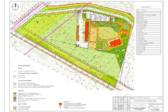
Project proposal, "Design of building area sports and leisure center "Maloe Ushakovo" that was developed by LLC "ALPN" under contract number 28/10 from 17.12.2010g. with «Vector Investments" on 8.0 hectares of the territory is provided for placing the objects of sport, cultural, entertainment and recreational facilities.
In accordance with the architectural and planning solutions to the projected area placed horse base "Outpost-Istra".
Horse riding - Centre for the provision of services hire of horses, the organization of horse riding trails, walking, holding shows and representations of horses.
Mounted on the territory of the base of the building will house catering for 250-300 cycles. places ("Saloon"), stables for 30 horses, farm buildings (coach-yard, storage of oats, hay and bedding storage, utility rooms and space for the zoo). The total projected area of the buildings and structures will be 1.85 square meters, including the "Saloon" (the object of catering to 250-300 cycles. Seats) - 0.64 square meters, with a stable placement for administrative purposes - 0.92 thousand square meters, the building is the repository of oats - 0.12 square meters and utility room to the zoo - 0.17 square metersThe list of objects that are placed within the planned equestrian center:
"Saloon" (a building point of catering) - 1130kv.m.
Stables - 900 sq.m.
Coach-yard shed - 160 sq. m
Storage for oats - 120 sq.m.
Storage for hay and bedding - 200 sq.m.
Utility Room Zoo - 170 meters
The total number of permanent employees will be about 10-12 people, temporarily (during mass events - up to 30 people).
As a result of the project a large part of the site occupied by equestrian database of agricultural land to 60%. It's - pastures and meadows.
Green spaces (green areas of general use, restricted use, children's play area, an arboretum, a zoo, playground, Platz) - 24.8%.
Asphalt pavement (asphalt economic zone, transportation, parking) occupy 11.8%.
The rest of the territory - an area 3.4% of projected construction of buildings and structures.
Indicator of intensity of use of the area - the density of the development fund will amount to 0.23 square meters of total area. / Ha, which corresponds to a low degree of land use. Percentage built-up area - 3.4%
3. The first phase of construction
Implementing the first phase of construction is adopted in this project until 2014. Basic principles of selection of priority measures include:
- The complexity and interrelatedness of the decision of all issues (architectural and spatial organization of the territory, the development of engineering and transportation) with the construction of new facilities;
- Link the priority actions of the territory with the prospects of economic, territorial and urban development of the territory of a rural settlement Buzharovskoe as a whole.
The project activities of the project carried out in one place, so the technical and economic characteristics of the territory in the first phase of construction and design life are the same.
4.The main technical and economic indices
5.The scheme of grading and engineering preparation of territory
For engineering training area it is necessary to perform the following activities:
vertical organization of the relief plan;
collection and drainage of surface water.
The scheme of grading done in conjunction with existing marks. The existing complex terrain is characterized by elevations 198.40 - 203.70. Stoke atmospheric water surface is designed for trays with the release in road gutter inlets projected a closed system drainage.
Grading scheme is executed with maximum preservation of existing topography.
Design deviations accepted in accordance with the norms SNiP 2.07-89 and fluctuate in the range 5 - 39.3 ppm.
The road surface is asphalt and parking provided with the device borders of typical concrete elements, and the paving of walkways and sidewalks - from concrete slabs and spets.smesi.
The mold is removed from the proposed area to a depth of 0.20m, stored and later used to raise a territory at the device lawns.
6.Transport service
6.1. Status quo
The territory of the planned sports and leisure center is situated in Istra, Moscow Region metro area between the villages of Leonov and Kartseva. Transport connection area of the planned deployment of sports and leisure center with villages and towns of the Istra region is carried out on the road "Volokolamsk Highway - Buzharovo - Saveliev - Rumyantsevo."
Highways
The road "Volokolamsk Highway - Buzharovo - Saveliev - Rumyantsevo" is a highway of regional significance III technical category. In this area the width of the carriageway of the road at 6 am on the carriageway road markings applied. In the markup is allocated two lanes for vehicular traffic in both directions. Artificial light from the land the road is missing.
6.2 Project offers
Project proposals for the transportation service area of sports and leisure center are designed to streamline and ensure the safe movement of vehicles and pedestrians, for the purpose of transport services and to determine placement of parking.
External transport connections of the territory will be carried out on the road of regional significance "Volokolamsk Highway - Buzharovo - Saveliev - Rumyantsevo."
The project includes two planned local street, road transport to travel to the area of sports and leisure center. Entry and exit into the territory of sports and leisure center is planned with local streets, located north of the territory. Departure on a highway "Volokolamsk Highway - Buzharovo - Saveliev - Rumyantsevo" is on the proposed local street located to the west of the area of sports and leisure center.
The project provides for reconstruction of the road "Volokolamsk Highway - Buzharovo - Saveliev - Rumyantsevo" maintaining two lanes of roadway and an increase to 7.00 m is also a device on the Verge of 2.50 m on each side of the road (0.50 m reinforced strip shoulders on each side of the road). The width of the roadway of streets is taken to be 8.00 m (4.00 m - width of traffic lanes in each direction of travel based on it konevozki). Planned cross-sections of streets and road are shown in the sheet "scheme of the road network and traffic" (sections 1-1, 2-2, 3-3) ..
By road junction near to her local streets constructed transitional and acceleration lanes. Departure from the proposed street to the highway in both directions by road traffic. Parameters of speed change lanes and radii of curves of the road junction and the proposed streets are accepted in accordance with SNiP 2.05.02-85 "Highways" and can be further refined according to specifications GU MO "Oued MO" Mosavtodor. "
On roads and streets will cause the appropriate road markings and install appropriate traffic signs in compliance with GOST R 52289-2004 "Technical means of traffic. Rules of road signs, markings, traffic signals, road barriers and guiding devices, "GOST R 51256-99" road markings. General specifications "and GOST R 52290-2004" Road signs. General specifications ".
Departure from the territory of vehicles sports complex is in the gearbox to the street located north of the territory. Departure is in both directions of the street. Transportation provides access to the administrative building and parking lot designed for 13 cars. East of the junction to get to the street provides entry-exit to the open car park, designed for 68 cars. The minimum width of driveways 8.00 m radii of curvature of the carriageways on the driveways to the street closures adopted 8.00 m.Proezdy adopted the device of asphalt concrete pavement, storm sewer and private setting curbs. At night, all projected internal network is proposed to cover driveways with luminaries mounted on special masts.
Traffic on the driveways to the street closures controlled road signs and road markings.
Buildings and equipment for temporary storage of vehicles
The maximum lump sum estimated number of visitors to sports complex is 300 people. The number of permanent employees is 12 persons, temporarily - 30 people. Thus, according to TSN 30-303-2000 "Planning and construction of urban and rural settlements. Moscow region, "the maximum current fleet is 95 units. For visitors to provide 90 parking spaces for 30 parking spaces for 100 people. For employees five parking spaces at 15 car spaces per 100 employees.
In the area of an office building provides an open parking lot for 13 cars. Uncovered parking lot, located east of the main entrance, is designed for 66 parking spaces and has a separate entrance from the street. Just down the street of local significance are provided adjacent to the carriageway parking for 16 cars.
Thus, the total capacity of the public car parks in the study area is 95 cars.
On the highway, "Highway Volokolamskoe - Buzharovo - Saveliev - Rumyantsevo" is planned to place a stop of public transport to the south of the territory of sports and leisure center in the 400 meters available.
Pedestrian traffic on sidewalks are planned along the highway, streets and driveways. The intersection of pedestrian and traffic flows are equipped with pedestrian crossings (corresponding to the road markings and by appropriate traffic signs).
On the highway, "Highway Volokolamskoe - Buzharovo - Saveliev - Rumyantsevo" the pavementis provided with the width 1.50 m from the territory of sports and leisure center. Also, the sidewalk area under consideration relates to public transport. On the proposed local street located to the west of the sports and leisure center, includes wide sidewalks, 1.50 m on both sides of the roadway. On the proposed local street running from north of the territory, provided the pavement width of 3.00 m on the north side of the roadway. On the eastern side of sports and leisure center provides pavement width 3.00 m, connecting sidewalks, road and planned local streets.
The movement on the territory of sports and leisure center is planned for sidewalks and pedestrian paths 1.5-3 m wide, and allowed the movement of pedestrians on the roadway passes.
7. Proposals to establish red lines
Design by red lines is in the "Project planning area of sports and leisure center" Maloe Ushakovo "at the MoD, Istra district, etc. Leonov." The red lines are shown in the drawing area plan that is part of the main (approved) part of project planning.
In accordance with the Town Planning Code of the Russian Federation, "the red lines - lines that refer to existing, planned (modified, re-formed) the boundaries of common areas, the boundaries of the land on which there are power lines, communication lines (including those of outside plant ), pipelines, roads, railway lines and other similar structures. " "Public Areas - areas that are free to enjoy an unlimited number of persons (including squares, streets, driveways, embankments, squares and boulevards)."
The red lines are installed on the road of regional significance "Volokolamsk Highway - Buzharovo - Saveliev - Rumyantsevo" and planned streets within the boundaries of local razrab0tki project planning.
Proposals to establish red lines, as well as design, layout drawings of the act meets the requirements of the legislative, legal and regulatory documents, including:
Urban Development Code of the Russian Federation of December 29, 2004 № 190-FZ;
The Land Code of the Russian Federation of 25.10.2001 № 136-FZ;
Resolution of the Government of the Moscow region from 19.06.2006 N 536/23 "On approval of the composition and content of the draft plan area, the preparation is carried out on the basis of territorial planning documents of the Moscow region and on the basis of territorial planning documents of municipalities of the Moscow region";
"Standards of allotment of land to accommodate the road and (or) road service facilities", approved by the Government of the Russian Federation of 02.09.2009 № 717;
TSN PZP 99 MO (TSN 30-303-2000 MO), "Planning and construction of urban and rural settlements";
SP 42.13330.2011;
SNiP 2.05.02-85 * "Highways";
RDS 30-201-98 "Instructions on how to design and establish red lines in the towns and other settlements of the Russian Federation", adopted by Resolution of Construction Committee of Russia on April 6, 1998 № 18-30.
The width of the red lines of the road "Volokolamsk Highway - Buzharovo - Saveliev - Rumyantsevo" adopted by 57.00 meters, taking into account the norms of allotment of land to accommodate the road.
The width of the red lines of the proposed local street located to the west of the area of sports and leisure center, is taken to be 22.00 meters on the proposed local street located north of the territory in question, - 26.00 pm
Established by the red lines are required to comply with all stakeholders in the construction of urban development of new and reconstruction of existing facilities, as well as the formation of land boundaries. Approval of the red line does not entail the termination of the rights of businesses and individuals on the existing land and other real estate, and is the basis for subsequent decision (if necessary), making the seizure, including by foreclosure, land for implementation of state and municipal needs for the development of transport and engineering infrastructure.
Line Indent set to determine where the allowable placement of buildings, structures and facilities. The formation of the indentation of lines was carried out in view of the proposed building adjacent to the established red lines. Line indentation set at a distance of 5 meters from the red lines.
Line indent in the future may be adjusted at the stage of architectural design.
The points are tied to the boundaries of the calculation of geodetic coordinates in a coordinate system in 1963 for the subsequent development of the red lines in the surrounding areas streets and roads.